 By Bob Currie, Vessel Examiner
United States Coast Guard Auxiliary Station Galveston Flotilla.
Clouds are made up of minute water droplets or ice crystals that have condensed from water vapor in the atmosphere. Clouds come in many different sizes and appearances but are classically grouped by the following categories:
The Station Galveston Flotilla of the US Coast Guard Auxiliary operates out of the USCG Station Galveston base on Galveston Island. They provide assistance to the Coast Guard by providing maritime observation patrols in Galveston Bay; by providing recreational boating vessel safety checks; and by working alongside Coast Guard members in maritime accident investigation, small boat training, watch standing, and property administration.
By the height of their bases
- Low: less than 6,500 ft (2,000 m); mostly water droplets
- Middle: 6,500 to less than 20,000 ft; mostly water, some ice
- High: 20,000 ft. (7,000 m) or above; ice particles
By their appearance
- Cumuliform (lumpy, heaped): Cumulus
- Stratiform (flat, uniform): Stratus
- Cirriform (wispy): Cirrus
A separate category is Clouds of Vertical Development (cumuliform).
Nimbus clouds are clouds that produce precipitation that reaches the ground in the form of rain, snow, or hail. The two basic types of nimbus clouds are cumulonimbus and nimbostratus.
Types/
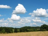
Cumulus- the Fair Weather Clouds
Ordinary cumulus clouds are small, puffy clouds. They have very little vertical development, and rarely produce precipitation. When they are low in the sky, they are simply called stratus clouds. As long as they are well-spread like these clouds, they are of no danger to those on the water.
Cumulonimbus
The name for this type of cloud is a combination of the words cumulus and nimbus. Since nimbus means rain, this is simply a cumulus cloud that is producing rain. When you are on the water, look out for cumulus clouds that begin to aggregate and form rain clouds.
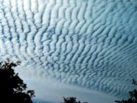
Altocumulus
Altocumulus (Alto = high, cumulus = heaped) are middle altitude clouds that do not produce precipitation. They can be arranged randomly, or in rows of clumps that look like streets. The “streets” indicate the direction of the wind. These clouds are commonly found between warm and cold fronts in a depression. These are WARNING clouds, as they frequently signal the development of thunderstorms later in the day.
Cirrocumulus
Cirro means “curl of hair.” They appear as small, high, patched clouds, in rows. Cirrocumulus clouds in old days were called a mackerel sky, and were the second type of WARNING cloud. They show that the upper level is unstable. In the winter they can indicate good weather, but when associated with cirrus and lowering clouds, it can storm within 24 hours.

Stratus
Stratus clouds are flat and uniform. They can be thin or thick, based on how much moisture they contain. When seen from above, they are white, and they do not produce any precipitation.
Altostratus
Altostratus clouds are simply stratus clouds found at the middle range. They can be thick (can’t see the sun) or thin (sun is partially visible. When thin, there will be a corona around the sun or moon.
Nimbostratus
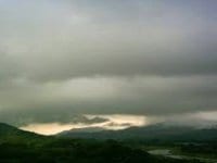
Nimbostratus clouds are simply stratus clouds that have thickened and produced precipitation. They are typically fairly dark as seen from below. You can often see shafts of rain below them. Nimbostratus clouds often develop into thunderstorms.
Cirrostratus
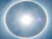
Cirrostratus clouds look like altostratus clouds, but they are formed in the high range and the moisture they contain is always in the form of ice. It is often difficult to tell altostratus from cirrostratus, but if the sun or moon is visible, there is a good clue. Altostratus is usually made of water droplets and cirrostratus is usually made of ice crystals. Water droplets scatter sunlight, making it look like there is a crown around the sun. It is called a corona. Ice particles refract light and make it look as if the sun (or moon) appears to have a halo (it is in fact called a halo). Cirrostratus clouds typically take the form of a white veil. Cirrostratus clouds are also WARNING clouds, and can be a sign that precipitation might follow in the next 12-24 hours, or as soon as 6-8 hours if the front is fast moving.
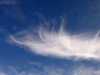
Cirrus
Cirrus clouds are found only in the high range, and are made up of ice crystals. The long wisps often found in these clouds are called mares’ tails. They are often mixed with cirrostratus clouds. Cirrus clouds with long wisps indicate instability in the high range.
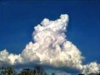
Towering Cumulus
Towering cumulus clouds are cumulus clouds that have grown very tall. They are a form of cumulus cloud that can be based in the low or middle height ranges, but the top reaches into the high range. These clouds form as air moves upward, which causes instability. These clouds can produce fair weather waterspouts, which tend to perish after precipitation or strong downdrafts form. These clouds often signal an approaching front, and any rain may be accompanied by thunderstorms. These are intermediate form clouds, and often develop into cumulonimbus clouds.
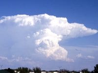
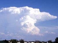
Cumulonimbus
Cumulonimbus is a dense, towering vertical cloud, formed from water vapor carried by powerful upward air currents. They can have rounded tops or flat, anvil tops of cirrostratus. They are almost always thunderstorms. They can vary in size from ordinary thunderstorms up to super cells that cover hundreds of square miles.
Thunderstorms
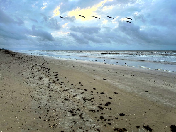
A thunderstorm is a violent, short-lived weather disturbance that is almost always associated with lightning, thunder, dense clouds, heavy rain or hail, and strong, gusty winds. Thunderstorms arise when layers of warm, moist air rise in a large, swift updraft to cooler regions of the atmosphere. Thunderstorms are dangerous not only because of lightning, but also because of the strong winds and the rough, confused seas that accompany them. On cloudy days, the prudent boater keeps an eye to the sky in order to have early warning when a thunderstorm develops. Try not to let a thunderstorm cut you off from your route to port. Head in before you get caught.
Lightning
Lightning is a potentially life-threatening phenomenon associated with some storms. Not all storms are thunderstorms, but all thunderstorms have lightning. Lightning occurs when opposite electrical charges within a thundercloud, or between a cloud and the earth, attract. It is actually a rapid equalization of the large static charges built up by air motion within the clouds. Lightning is very unpredictable and has immense power. A lightning “bolt” usually strikes the highest object on the boat, generally the mast or radio antenna. A mast with a full grounding harness affords excellent protection. In addition to using the radar to find the range of a thunderstorm, the boat’s distance from a thunderstorm can be estimated by knowing it takes about five seconds for the sound of thunder to travel each mile.
Waterspouts
A waterspout is a rotating column of air, usually pendant from a cumulus or cumulonimbus cloud, that forms over water and whose circulation extends to the surface. There are two types of waterspouts:
- Violent convective storms over land moving seaward (tornadoes)
- Storms formed over sea with fair or foul weather (more common than tornadoes)
Waterspouts develop as a funnel-shaped cloud and when fully developed extend from the water’s surface to the base of a cumulus cloud. The water in a waterspout is mostly confined to its lower portion. The air in waterspouts may rotate clockwise or counterclockwise, depending on the manner of formation. Waterspouts vary in diameter, height, strength and duration, and are found most frequently in tropical regions, but are not uncommon in higher latitudes. They are not always harmless, and, depending on size, can be a great source of danger to boaters.
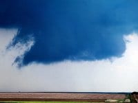
Tornado Formation
One feature of thunderstorms that warns of the formation of tornadoes is a wall cloud forming at the base of the storm. It can often be seen as beginning the rotation that will lead to the tornado.
Tornadoes
Scientists are beginning to realize that there is a direct correlation between lightning and tornadoes. While lightning is certainly a predictor of tornadoes, some scientists think that lightning may actually play a part in creating tornadoes. The type of lightning associated with tornadoes is in-cloud lightning, that is, the flashes that occur within a cloud that never make it to the ground. As a storm builds and more ice particles collide in a cloud, the rate of lightning flashes increases. This increase is often tied to a future growth in a storm’s intensity.
For more information on boating safety, please visit the Official Website of the U.S. Coast Guard’s Boating Safety Division at www.uscgboating.org. Questions about the US Coast Guard Auxiliary or our free Vessel Safety Check program may be directed to me at [email protected]. I am available to perform free Vessel Safety Checks, and I will come to your location to perform them. SAFE BOATING!
[6-24-2019]
 Posted in