
 By Bob Currie, Recreational Boating Safety Specialist
U. S. Coast Guard Auxiliary Station Galveston Flotilla
Before the 18th-century development of the marine chronometer by John Harrison and the lunar distance method, dead reckoning was the primary method of determining longitude available to mariners such as Christopher Columbus on his trans-Atlantic voyages. Tools such as the traverse board were developed to enable even illiterate crew members to collect the data needed for dead reckoning. This column will look at some of the aids to navigation developed over the centuries.
The Station Galveston Flotilla of the US Coast Guard Auxiliary operates out of the USCG Station Galveston base on Galveston Island. They aid the Coast Guard by providing maritime observation patrols in Galveston Bay; by providing recreational boating vessel safety checks; and by working alongside Coast Guard members in maritime accident investigation, small boat training, providing a safety zone, Aids to Navigation verification, in the galley, on the Coast Guard Drone Team and watch standing.
Follow the Sun, Wee-ooh
Ancient navigators rarely left sight of land; instead they followed the coast. This method, called coastal navigation, is still a popular way to move along the coast. But even in ancient times there were navigators who dared to venture out of sight of land. Their method of navigation is best explained in a Del Shannon song, Keep Searchin:
Searchin’, searchin’, she’ll be by my side
If we gotta keep on the run we’ll follow the sun-ah, wee-ooh
Follow the sun-ah, wee-ooh
These navigators were the first Round Earthers, and they knew that if they followed the sun they would be heading west. The next improvement in navigation was dead reckoning.
Dead Reckoning
Dead reckoning begins with a known position which is then advanced on a chart using time and speed to determine distance travelled. A chip log was tossed off at the bow of the ship and the time it took to traverse between two points on the side of the ship was used to calculate the relative speed through the water (STW). Multiply the STW by the elapsed time and you had the distance traveled. Columbus was one of the first navigators to keep detailed logs. From those logs we know that Columbus primarily used dead reckoning. On his first voyage, Columbus used a magnetic compass to hold to a westward course for weeks at a time.
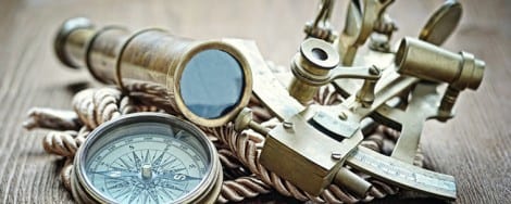
The Magnetic Compass
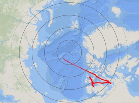
The magnetic compass is over 2000 years old. It’s first documented use in navigation was around 1190, well before Columbus. Even so, it has not been replaced as a navigation tool on modern vessels. If you have a GPS and use that to navigate, you should have a compass as a backup instrument in case you lose your GPS. That said, a compass will not adjust for the direction and speed of any ocean currents, known as set (direction) and drift (speed). Everyone knows that a compass points toward the north pole, right? Well, sort of. It points to the magnetic north pole. The magnetic north pole is located in Canada now. The diagram shows the geometric north pole and a track of the annual changes in the magnetic north pole. The magnetic pole recently moved 50 miles in one year.
Give Me a Little Latitude Here
Navigators have been able to determine their latitude for centuries. It is such a simple process that it will blow your mind.
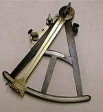
Quadrant- source www.nps.gov
All you have to do is be able to see the Big Dipper and have a navigational quadrant or other way to measure the angle between the horizon and the last star in the handle of the Big Dipper, also know as Polaris or the North Star. That angle is your latitude in degrees! The more detailed the quadrant, the more accurate the measurement. Columbus used a quadrant in his voyages along with a magnet to navigate. But Columbus had little luck using the quadrant. While the quadrant he used was accurate to one degree, Columbus’s measurements were off as much as 22 degrees. A rolling ship and little training were what kept him from making correct latitude determinations. No wonder he thought he had reached India.
The Longitude and the Short of It
As mentioned earlier, Latitude was the easiest part of a ship’s position to determine. Prior to the invention of the sextant and celestial navigation, sailors relied on their distance from The Royal Observatory at Greenwich Park in London to determine their longitude. They used simple time and distance calculations that were very labor intensive. First, a cabin boy had to turn a 30-minute hourglass, well, every 30 minutes. You can be sure this was a far from precise method of determining the time elapsed since the beginning of the voyage, but that along with the speed of the ship is how a ship determined its longitude, which is the vertical measurement in degrees from the Royal Observatory. Because the hourglass was such a poor method of determining elapsed time, English Parliament established the Longitude Act in 1714. The Longitude Act established a series of prizes for anyone who could determine a method for measuring longitude to one degree. That may sound like a precise measurement, but at the equator one degree of longitude is equal to 60 nautical miles. The prize money increased if accuracy was more precise, with the most accuracy pegged at one minute of longitude, or one nautical mile at the equator. There were several winners. One winner developed the Lunar Distance Time Calculator to determine longitude. The scientist who won the most money from the longitude competition won with his invention of the marine chronometer. Standard clocks of the day, which used a pendulum, worked poorly on rolling ships, while cabin boys turning a 30-minute hourglass every 30 minutes was only slightly more accurate. I wonder if they reduced the number of cabin boys when marine chronometers were introduced.
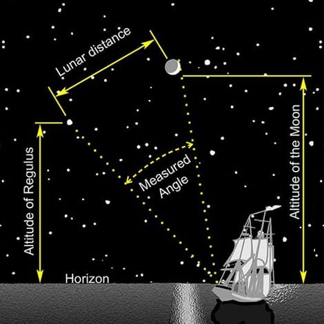
Lunar Distance Time Calculation Method
The lunar distance method of celestial navigation was a huge improvement in navigation. The navigator used a quadrant to determine the angle between the moon and a known star (Regulus in the example). The angle and the time of the measurement were looked up in a table, and through a series of complicated mathematical calculations the longitude was determined.
https://commons.wikimedia.org/w/index.php?curid=3209046
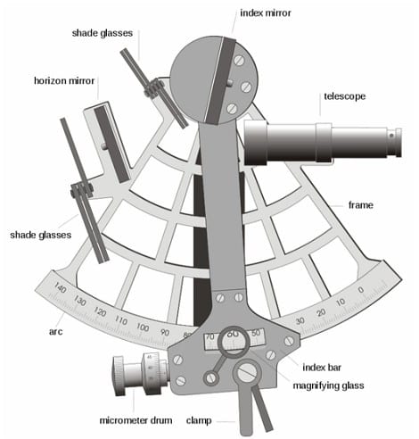
Celestial Navigation by Sextant
Celestial navigation is still used today to determine position. US Coast Guard cutters routinely use celestial navigation on long voyages up or down the coast and use GPS as a backup only. The primary instrument used in celestial navigation is the sextant. The sextant is used to take an angular measurement (called the declination) between the horizon and the sun, the moon, or certain stars. A sextant is similar to a quadrant, but it much more precise. At a given time, any celestial body is located directly over one point on the Earth’s surface. The latitude and longitude of that point is known as the celestial body’s geographic position (GP), the location of which can be determined from tables in the nautical almanac for that year. The measured angle between the celestial body and the visible horizon is directly related to the distance between the celestial body’s GP and the observer’s position. After some computations, referred to as sight reduction, this measurement is used to plot a line of position (LOP) on a navigational chart or plotting worksheet, the observer’s position being somewhere on that line. Sights on two celestial bodies give two such lines on the chart; where the two lines intersect is the observer’s position. One of my favorite scenes from the movie Mutiny on the Bounty shows Marlin Brando in the background using a sextant to take a reading on the noontime sun. This is all in the background of the scene. As soon as he takes the reading, Brando/Mr. Christian looks at the sextant and says, “Latitude such and such, longitude such and such.” If only it was that simple!
https://commons.wikimedia.org/w/index.php?curid=1314046
Global Positioning System
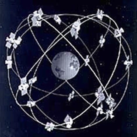
These days we have the Global Positioning System (GPS) to help us locate our position on the earth’s surface. There are those of us who remember a time when there was no such thing as GPS; in fact, we remember the first satellites launched into orbit: Sputnik 1 for the USSR in 1957, and Explorer 1 for the US in 1958. The first GPS satellite was launched in 1978. There are 24 satellites in the NAVSTAR Global Positioning System. The Global Positioning System is a U.S.-owned utility that provides users with positioning, navigation, and timing (PNT) services. This system consists of three segments: the space segment, the control segment, and the user segment. The U.S. Air Force develops, maintains, and operates the space and control segments. GPS has become so affordable to the recreational boaters that it is rare to find a boat that doesn’t have it. You can download a very good GPS app on your smartphone for almost nothing. Columbus might have found his route to India if he had GPS.
http://www.oceanservice.noaa.gov/topics/navops/positioning/welcome.html
Public Domain, https://commons.wikimedia.org/w/index.php?curid=1898166
Summary
There have been many advances in navigation over the centuries. Old Cristobal Colon used dead reckoning to find the New World. He experimented with celestial navigation, but every one of his recordings was off- way off. His compass and the prevailing winds and currents got him where he wanted to go, although he never quite figured out where that was. On his fourth voyage, his return trip was as a paying passenger. Two major inventions that revolutionized early trips across the Atlantic were the marine chronometer and the sextant (and its earlier variations). Both of those instruments, along with the 2000 year old magnetic compass, are still viable instruments today. If you are considering an ocean voyage, you should learn celestial navigation.
For more information on boating safety, please visit the Official Website of the U.S. Coast Guard’s Boating Safety Division at www.uscgboating.org. Questions about the US Coast Guard Auxiliary or our free Vessel Safety Check program may be directed to me at [email protected]. SAFE BOATING!
[Sept-28-2020]
 Posted in


Very interesting article! I’m an amateur astronomer and knew celestial navigation was developed by the seafarer but did not know much more than that a sextant was involved. Thanks for the history of marine navigation. Great info and easy to digest!