 By Bob Currie, Recreational Boating Safety Specialist
U. S. Coast Guard Auxiliary Station Galveston Flotilla
If you are a fan of the movie Airplane!, you should remember the line where the captain requests the copilot to “Give me a vector, Victor.” Even if you are not a pilot or a sailor, you may have some vague idea of the meaning of a vector. A vector is a graphical representation of a force combined with a direction and is shown on the charts below as a line with an arrowhead indicating the direction. The length of the line indicates the result of the combination of the two components. For example, a vector might represent the distance traveled using a particular heading over a period of time, such as a heading of 270 degrees at 10 knots for five hours. When using vectors on a chart, scaling is important. That is because vectors can be used for charting your course.
The Base Galveston Flotilla of the US Coast Guard Auxiliary operates out of the US Coast Guard base on Galveston Island. They aid the Coast Guard by providing maritime observation patrols in Galveston Bay; by providing recreational boating vessel safety checks; and by working alongside Coast Guard members in maritime accident investigation, small boat training, providing a safety zone, Aids to Navigation verification, cooking in base and station galleys and aboard cutters, and on the Coast Guard Drone Team.
Course Correction Vectors
In the simplest terms I can think of, when discussing marine navigation, a course correction vector is the course you want to steer and the speed you want to make if you want to get from point A to point B taking into consideration the forces of current speed and current direction and correcting your steering course for the combination of those forces. A course correction vector can easily be calculated when you know the current’s set (the direction to which a current flows) and drift (the speed of the current). In the example shown below the set and drift are known.
Current Sailing
Current sailing is the process of allowing for the effect of current when determining a course to steer in order to get from Point A to Point B, also known as “course made good.” Current sailing calculations may also be used to correct course as well as speed for the effects of known (measured or calculated) or suspected current in order to arrive at the intended destination at the intended time. This means not only are you correcting your course direction but you are also determining the speed required to get to Point B by a certain time. The time element becomes very important when the destination port is greatly affected by the tide. Some ports are inaccessible at low tide.
The Current Triangle
The current triangle is a graphical representation of the effects of current. Each line of the current triangle is a vector that graphically demonstrates both magnitude and direction. Keeping the same speed in the calculation, the current effect can make your trip take longer or shorter, depending on the direction of current (drift). Let’s look at a sample problem. The diagrams used here are not to scale and are for illustrating how course correction vectors can be used. Standard charting symbols are not used here as they would take too much time to explain.
The Problem: Sail from Point A to Point B
In this problem we have a boat 100 miles offshore that wants to sail to Port Aransas. The captain knows his location and plots a direct route to Port Aransas as shown in the diagram below. He sets his speed at 20 knots and his course at 290 degrees, which according to the chart should put him right off Port Aransas in 5 hours. If there were no currents in the Gulf of Mexico, this plan would work. But there are always currents in the Gulf of Mexico, and as you see in the second diagram the captain finds himself 5 hours later at X, just off Port Lavaca. The captain has experienced the effect of current.
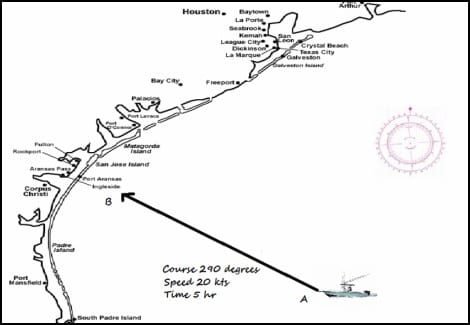
Diagram 1: Plotted Course is executed.
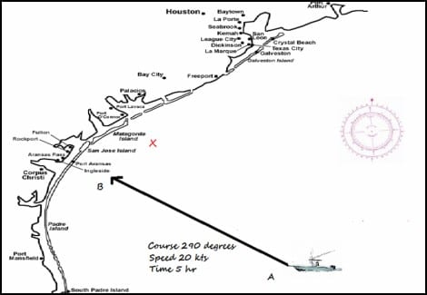
Diagram 2: X marks where the boat ended up after 5 hours at a heading of 290 degrees.
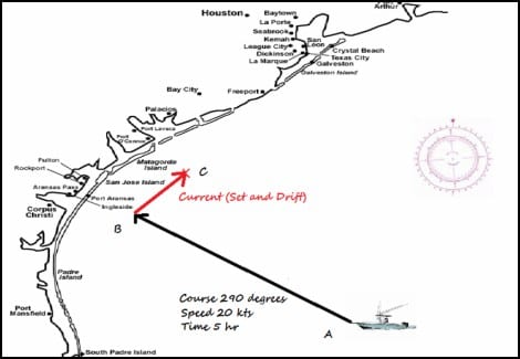
Diagram 3: The line from B to C is the Current Vector.
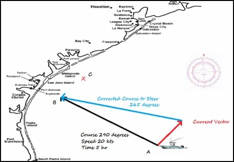
Diagram 4: Current Vector and Corrected Course Vector (translocated to point A)
A Better Method of Navigation: The Current Triangle
The captain that uses the navigation triangle to set course uses much less fuel and time than the captain that sets a course based on the location of Point B without considering the effect of current. The captain who ends up at Point C must now change course and move directly against the current to get to Point A. The captain who uses a corrected course to get to Point B only has to partially fight the effect of the current. The captain that takes into consideration the effect of current also saves time as well as fuel, as using a corrected course vector lets you take advantage of any additive effect the current may have. If the effect of the current is negative, then it will take longer to get to Point B, but if time is of the essence the captain can increase speed based on the length of the corrected course vector and arrive on time.
Summary
This is a very simplified explanation of Current Sailing. By taking into account the effect of the current a captain can save fuel and time.
For more information on boating safety, please visit the Official Website of the U.S. Coast Guard’s Boating Safety Division at www.uscgboating.org. Questions about the US Coast Guard Auxiliary or our free Vessel Safety Check program may be directed to me at [email protected]. I am available to perform free Vessel Safety Checks, and I will come to your location to perform them. SAFE BOATING!
[Jan-4-2021]
 Posted in