 By Bob Currie, Vessel Examiner
United States Coast Guard Auxiliary Station Galveston Flotilla
Weather in general is one of the most important factors in our lives. We need to know what the weather forecast is so we can dress accordingly as well as act accordingly. The cause of most weather phenomena is uneven heating of the earth’s surface. Wind and weather are almost the same thing, as wind drives the weather.
The Station Galveston Flotilla of the US Coast Guard Auxiliary operates out of the USCG Station Galveston base on Galveston Island. They provide assistance to the Coast Guard by providing maritime observation patrols in Galveston Bay; by providing recreational boating vessel safety checks; and by working alongside Coast Guard members in maritime accident investigation, small boat training, watch standing, and property administration.
Some important terms as they pertain to wind include:
- Apparent wind is the direction and force of the wind relative to a moving vessel. The motion of a vessel underway makes the effective wind vary from the actual wind direction.
- True wind is the actual direction and force of the wind.
- Backing wind is defined as wind change direction in a counter-clockwise direction in the northern hemisphere (clockwise in the southern hemisphere).
- Veering wind is a clockwise shift in the wind.
Local Effects on Wind
The largest temperature swings are with thee seasons, but with the same input, the land heats faster than the ocean. The uneven heating and cooling of the land and ocean causes certain winds to develop near the shore. We call the winds that develop locally due to this uneven heating a sea breeze or a land breeze.
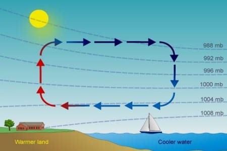
Sea Breeze
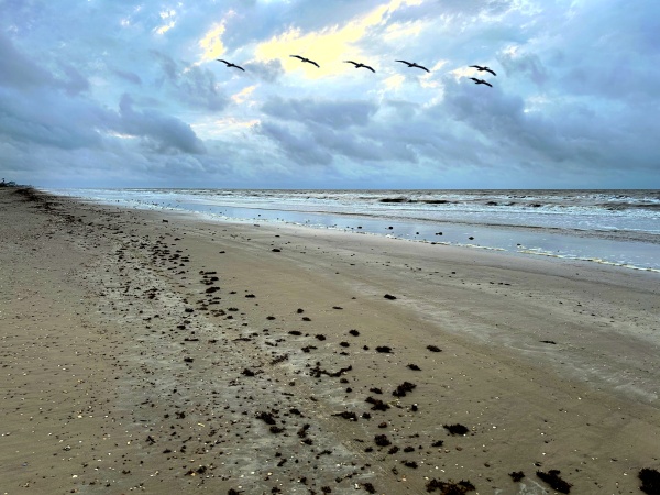
Boaters get underway in the calm hours of the cool early morning. By afternoon, when they try to get home, the bay or ocean is so choppy that they may find themselves in need of assistance. This calm to choppy tendency from the morning to the afternoon is due to winds that develop into what is called a sea breeze. The wind causes the waves to develop. The wind changes so drastically because as the sun warms the earth, the land warms faster than the surface of the water and radiates heat to the overlying air, warming it. The warm air rises, reducing the atmospheric pressure in the area. The air offshore over the ocean is cool, and cool air is dense and heavy. The cool air from the offshore flows inland in an attempt to equalize the pressure differential caused by the rising air. This flow produces the wind. Sea breezes typically reach their highest speeds during the period of maximum heating, around mid-afternoon.
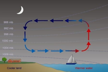
Land Breeze
After sunset, the inland area cools more quickly than the water, and the wind diminishes. In some areas a land breeze can be established late at night or early in the morning. For this breeze to occur, the sea surface temperature must be higher than the air temperature over land, along with weak winds prior to the breeze.
Weather Fronts
Fronts are the boundaries between two air masses. Fronts are classified as to which type of air mass (cold or warm) is replacing the other. For example, a cold front demarcates the leading edge of a cold air mass displacing a warmer air mass. A warm front is the leading edge of a warmer air mass replacing a colder air mass. If the front is essentially not moving, it is called a stationary front.
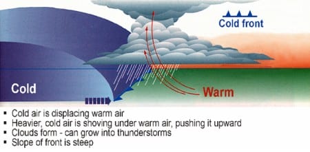
Cold Front
When a cold front moves into space occupied by warmer air, it forces the warmer air to rise up and over the leading cold edge. This is because cold air is denser, or heavier than warm air. As warm air rises, it mixes with the cold air and condenses into large clouds. A line of clouds, sharp changes in wind direction, and sharp changes in temperature are most frequently associated with a cold front. A cold front moving in from the northwest can produce thunderstorms, hail, and then rapid clearing. A series of brief showers accompanied by strong, shifting winds may occur along or some distance ahead of a cold front. After a cold front passes, the barometric pressure usually rises, often with clearing skies.
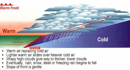
Warm Front
A warm front occurs when an advancing warm air mass reaches colder air and rides up over it, and the atmospheric pressure drops. A warm air mass is characterized by stability. A frontal thunderstorm is caused by a warm air mass rising over a cold air mass. Clouds form at low levels and rainfall is more moderate and over an extended period of time. A typical warm front will bring rising temperatures and a falling barometric pressure.
Stationary Front
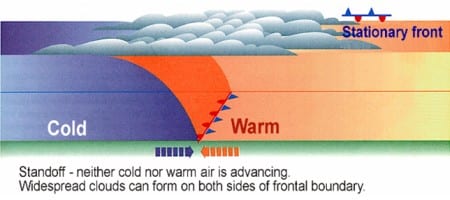
Stationary fronts remain in nearly the same place, sometimes for days, wandering back and forth. A stationary front occurs when a cold air mass and a warm air mass meet and there is no horizontal motion of either mass, bringing conditions of rain and clouds much like a warm front.
Occluded Front
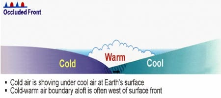
Occluded fronts typically involve three different air masses: a cold air mass, a cool air mass, and a warm air mass. Cold fronts typically move faster than warm fronts, so they “catch up” to warm fronts. As the three fronts merge, an occluded front forms. In the occluded front, the cold air mass undercuts the cool air mass, further lifting the already rising warm air. Rain clouds develop, and the cold air mass pushes rain ahead of it.
High and Low Pressure
A succession of pressure systems continually move across the globe from west to east bringing constantly changing weather. The horizontal motions of air (wind) are caused by differences of atmospheric pressure as air moves from areas of high pressure (which are usually cool) to areas of low pressure (which are usually warm). High and low refer to the relative barometric pressures found in the center of each air mass. At the surface, wind flows counter clockwise (called cyclonical) and inward around a low pressure area and clockwise (cyclonical) and outward around high pressure area.
Cyclones
A cyclone is an area of relatively low barometric pressure that contains a rotating air mass that is roughly circular in shape. The rotation is counter clockwise and outward from the center of the air mass. The resulting upward movement of air results in cooling. Because cool air is capable of holding less moisture than warm air, a condition favorable to the development of clouds and precipitation develops. The precipitation is usually continuous rain and generally stormy weather.
Anticyclones
An anticyclone is an air mass with a relatively high barometric pressure. The winds tend to be clockwise and inward. The effects of surface-based anticyclones include clearing skies as well as cooler, dryer air.
Locating High and Low Pressure Areas
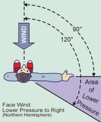 If you are in the northern hemisphere and face into the surface wind, the center of the low pressure is to your right and somewhat behind you. Under the same conditions, the center of high pressure is towards your left and somewhat in front of you. This phenomenon is called the Buys-Ballot Law.
Summary
Knowledge of how the weather develops and changes can help you decide if and when you need to head to a safe port. Pay attention to weather forecasts, but also understand that local changes can be quick and severe and learn to recognize the warning signs.
For more information on boating safety, please visit the Official Website of the U.S. Coast Guard’s Boating Safety Division at www.uscgboating.org. Questions about the US Coast Guard Auxiliary or our free Vessel Safety Check program may be directed to me at [email protected]. I am available to perform free Vessel Safety Checks, and I will come to your location to perform them. SAFE BOATING!
[7-1-2019]
 Posted in