 By Bob Currie, Vessel Examiner
United States Coast Guard Auxiliary Flotilla 081-06-08
USCG Auxiliary Flotilla 081-06-08 is based at Coast Guard Station Galveston. The Auxiliary’s vessel examiners perform safety checks on all types of recreational boats. The list of equipment required by federal law is very minimal; however, the Coast Guard has several recommendations for consideration by the prudent and safe recreational boater. Many of the recommendations for recreational boaters are actually required of commercial vessels.
Offshore Operation – EPIRB, Life Raft, and Additional Communication Equipment
Boaters who operate offshore should carry additional equipment beyond that mandated by federal or state regulations. Among these items one may carry, depending upon how far from shore they intend to operate, are an Emergency Position Indicating Radio Beacon (EPIRB), which enables rescue personnel to determine a boat’s location; an inflatable life raft; an immersion suit for each person on board, if the vessel is to operate in cold waters; and VHF-FM or high-frequency transceivers suitable for the operating area, along with backup radios and cell phones.
Locator Beacons
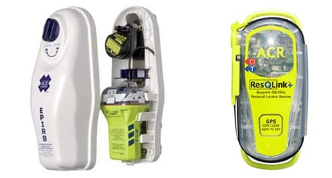
An Emergency Position Indicating Radio Beacon (EPIRB) and Personal Locator Beacons (PLB) are used to alert search and rescue services in the event of an emergency. It does this by transmitting a coded message on the 406 MHZ distress frequency via satellite and earth stations to the nearest rescue coordination center. Some EPIRBS also have built-in GPS, which enables rescue services to accurately locate you +/- 125 meters.
A properly registered EPIRB and PLB are some of the most reliable and expeditious ways for the Coast Guard to receive notification of distress when properly registered and mounted. Registration is required by federal regulation (47 CFR 80.1061). Boaters should ensure that EPIRBs are mounted or stored securely and in a location that will enable the EPIRB to float free (ex. outside cabin for mounted EPIRB) or easily accessible (ex. in pants pocket or primary life jacket pocket for PLB) in case of capsize or other emergency. EPIRBs may be found in the $500-750 range. While some are manual release, some have an automatic release feature in case of submersion. PLBs, designed to be attached to or carried in a person’s life jacket, may be found for around $250-350. Pictured below is an EPIRB with automatic release on the left and a PLB on the right.
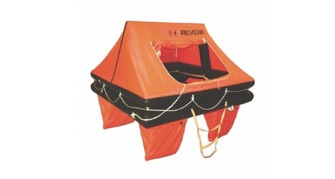
Life Rafts
Life rafts can serve as a survival platform for an extended time. Operators should be sure that the raft is large enough to hold the maximum number of persons that will be aboard. The raft should be equipped with a package of appropriate emergency equipment (including food and water), and serviced professionally according to the manufacturer’s instructions. Although not cheap, a decent life raft may be purchased for around $1,000 fully equipped with visual distress signals.
Nautical Charts
Nautical charts provide important information for navigating waterways and planning trips. They show the nature and shape of the coast, water depths, and characteristics of the bottom, prominent landmarks, port facilities, navigational aids, marine hazards, and other pertinent information. Charts are updated regularly by the National Oceanographic and Atmospheric Administration and sold as print on demand through NOAA certified agents, marine supply stores and chart vendors.
Boaters should be sure to use the most up to date charts available, and, when operating in coastal waters, obtain the largest scale charts they can, which show the greatest amount of detail about the area. Operators who use a chart plotter or GPS receiver in place of a paper chart should periodically buy or download updated charts. I recently installed a new GPS/Sonar unit on my boat, but I also have paper charts and study them prior to boating in new areas. While fishing charts are great to have also, they should not be used for navigation.
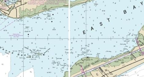
Above are grab shots of a section of the chart I use: NOAA Chart 11326, titled Folio Small-Craft Chart Galveston Bay. NOAA Gulf of Mexico charts may be found at http://www.charts.noaa.gov/OnLineViewer/GulfCoastViewerTable.shtml.
Charts may be downloaded for free to your computer at this site. There are several different download formats, including PDF.
For more information on boating safety, please visit the Official Website of the U.S. Coast Guard’s Boating Safety Division at www.uscgboating.org. Questions about the U.S. Coast Guard Auxiliary or our free Vessel Safety Check program may be directed to me at [email protected]. I am available to perform free Vessel Safety Checks, and I will come to your location to perform them. SAFE BOATING!
[11-27-2017]
 Posted in