 By Bob Currie, Recreational Boating Safety Specialist
U. S. Coast Guard Auxiliary Station Galveston Flotilla
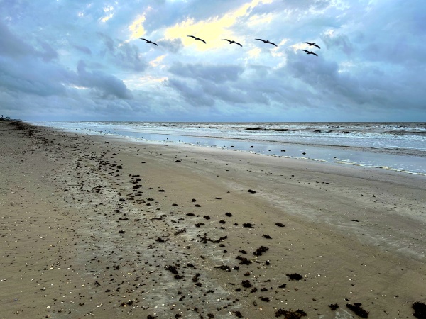
I live in a resort community on a 21-mile long narrow peninsula on the Gulf of Mexico. My house is raised 21 feet above sea level on pilings. From my deck I can look one way and see ships go by, and the other way and see tugs pushing barges in the Intracoastal Waterway (ICW). One of the most frequent questions we locals get is where’s the beach? What they mean is not answered by “this way” or “that-a way,” but instead they mean how close is the waterline to the dunes at a certain location. Many are asking so they can drive their vehicles on the beach, while others are wanting to know where they can pitch a tent for the night or park their RV overnight. The answer is never that simple for two phenomena routinely found on any coastline: wind and tide. Today we will talk about how they affect recreational boating.
What Are Tides
Let’s discuss the one known and predictable factor that affects our ability to launch and recover our boats: the tide. Tides are the rise and fall of sea levels caused by the combined effects of the gravitational forces exerted by the moon and the sun, and the rotation of the earth. Tide tables can be used for any given locale to find the predicted times and amplitude, known as the tidal range. The predictions are influenced by many factors including the alignment of the sun and moon, the phase and amplitude of the tide (pattern of tides in the deep ocean), the amphidromic systems of the oceans, and the shape of the coastline and near-shore bathymetry (shape and depth of the ocean floor). 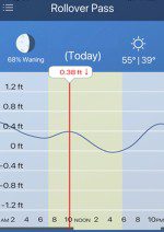 They are, however, only predictions; the actual time and height of the tide is affected by wind and atmospheric pressure. Many shorelines experience semi-diurnal tides—two nearly equal high and low tides each day. Other locations have a diurnal tide—one high and low tide each day. A “mixed tide”—two uneven magnitude tides a day—is a third regular category.
Tides can be likened to waves. You can watch a wave at the beach and see that the wave will crest in different places all along the wave. One portion of the wave will actually make landfall much sooner than another portion. If you can equate a tide to a wave, then you can understand why the high and low tides are much different at different locations. The tides along the Bolivar beaches (where I live) are approximately a minute apart per mile as you go east. Using my example chart, If I were located 8 miles west of Rollover Pass, if the high tide at Rollover Pass was at 10:18 AM then high tide would be at 10:07 AM at my location. The one mile a minute correction works pretty well for short distances (under 50 miles). Beyond that the wind can affect the high or low tide estimate. A good link to check tides may be found at www.saltwatertides.com . I use the free Tides app on my cell phone.
Wind and Tide Relevance
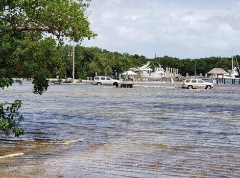
Besides the old rule of thumb that fish feed on a moving tide (going out or coming in), the min relevance of the affect of wind and tide is being able to launch your boat and being able to remove it from the water at the end of a trip. The two factors that affect that process are not enough water to launch or retrieve and too much water to launch or retrieve, and it is up to you to anticipate both possibilities so that you can launch and retrieve. More than once I have miscalculated the wind effect and come back to the ramp to find the parking lot under over a foot of water; not inside the truck yet, but difficult to see the road to the ramp and the ramp itself, which was completely covered with water.
When I launch and retrieve my boat, I only get the tires wet. I don’t immerse any metal part of my truck. Salt water does mean things to the underbelly of vehicles exposed to salt water. So, you can see why it is important to ensure that you will have a dry retrieval for your towing vehicle. When I launch at a marina that has employees on duty, I get the phone number for the marina so I can check on rising or dropping water levels that might make it difficult for me to retrieve my boat. Below is an explanation of tides and how tide apps work. Although a good tide app is quite valuable, it should not be the only thing that you depend on when launching and retrieving your boat.
Tide Generating Forces
The solid earth is not rigid. It undergoes plastic deformation due to the same gravitational interactions as the oceans. Earth tides, as they are called, are relatively small but readily measurable. As mariners, our concerns are about ocean tides. Tides should be thought of as being in the form of waves. These waves are thousands of miles in length. Their crests are the high tides, their troughs, the low tides, and the horizontal component of the water particles that make up the wave, the tidal currents. To complicate the matter, these waves combine to reinforce or interfere with each other in varying amounts, partially contributing to the wide differences in tidal characteristics as actually observed. The tide is fundamentally caused by gravitational interactions between the sun, moon, and earth. These interactions of the gravitational forces are the same as those causing the moon and earth to remain in their respective orbits. The gravitational effect of the moon on the tide is 2.16 times more influential in causing the tide than the sun, although the sun does produce a measurable amount of tide producing force.
Factors Contributing to Unpredictability
The Center for Operational Oceanographic Products and Services (CO-OPS) of the National Ocean Service (NOS), National Oceanic and Atmospheric Administration (NOAA) provides very accurate measurements of the tide over time at numerous locations throughout the United States and its territories. But, between the fundamental tide producing forces and the observed tide at a particular place and time, there is a vast area of numerous unknowns that can be referred to as terrestrial factors. Some of the factors that the unknowns are associated with are:
- The restrictive depths of the oceans not allowing the generated tidal wave to be in equilibrium with the rotation of the earth,
- Irregular ocean depths over which the waves must travel,
- Reflections and interactions of the waves from irregularly shaped continents,
- Bottom friction,
- Turbulence, and
- Viscosity of the water.
In addition to the terrestrial factors mentioned above there are also meteorological factors which, at some locations, cause large differences between the observed and predicted tide. Weather events such as hurricanes and tropical storms can produce significant differences between predicted and observed water levels. Wind, rain (associated with river runoff), and barometric pressure, even when not associated with a storm event, can also cause major differences between observed and predicted water levels. Those of us who live at the beach have observed times when there was more beach at high tide than there was at low tide, and we understand that this phenomenon is due to a strong south wind blowing the water further up the beach at low tide or a strong north wind blowing the water out at high tide. These variations in the apparent tide cannot be taken into consideration by long-term tide predictions. Instead, one must consider the effect of the wind on the predicted tide in order to judge where the real water level is going to be. When there is no wind, the tide prediction is usually spot on. During heavy wind cycles predicting the tide becomes much more difficult.
Tide Prediction Smoothing
The tide prediction you will find in almanacs and in popular cell phone apps is called the astronomic tide prediction. The words “tide,” as in “high tide,” and “water,” as in “high water,” have been used interchangeably in the historical development of tidal activity here in the United States. In the last few decades, “water” has been favored. Whenever ocean elevation measurements are made, the highs and lows include the astronomic tides and all other effects such as those caused by the winds and ocean currents. Therefore, “water” is the most appropriate term. In analyzing, studying, and predicting, however, “tide” is the most appropriate since the astronomic tide is the element that we can predict with the greatest accuracy and reliability.
Recently, the term “water level tidal prediction” has been introduced by CO-OPS to solve this semantic problem. The astronomic tide, which is predicted solely by taking into consideration the gravitational effect of the moon and sun, is merely a starting point in tide prediction. As mentioned, there are many factors that can skew a particular tide prediction. The meteorological effects are now taken into consideration, and thus help smooth out the terrestrial factors’ effect on the astronomical tide predictions.
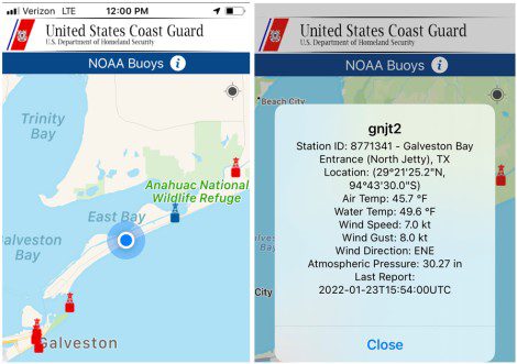
NOAA has thousands of satellite-linked weather buoys strategically placed on and near the coastline to help with tide predictions. These weather buoys can be located using the U.S. Coast Guard app, and the information they produce can readily be used by all mariners, including recreational boaters. You can pull up the data from a buoy and find out what is going on at that location prior to getting underway. You can use the water temperature to help you decide what type of clothing you need in case of accidental immersion; you can use the wind speed and direction to help you plan your fuel use as well as to help judge its effect on the tide. For example, I know that if I am launching in Galveston East Bay I should consider that a north wind is going to cause me to use more fuel going out than coming back in, and the wind will also increase the water level at the boat ramp, whereas a south wind will cause me to use more fuel returning to the ramp as well as lowering the water level at the ramp. All I have to do is add in the effect of the astronomical tide to the effect of the weather to help me decide the best time to launch my boat or retrieve it after a fishing expedition. If the wind activity is minimal, then the astronomical tide prediction is all I need to help plan my trip. You also need a plan B if the water level at the ramp from which you launched is too high or too low to retrieve your boat. With experience you will be able to use the predicted tide charts, the information from the NOAA buoys, and your own observations to ride the tides.
Summary
While tide charts can be quite useful in planning an excursion on the water, you must take other meteorological effects on water level into consideration. Concerns include the water level at the boat ramp, the water level at various coves and cuts, and the water level at shoal areas. You don’t want to get trapped in shallow coves or cuts, you don’t want to run aground, and you want to be able to trailer your boat at the end of the trip. When the weather is windy or the wind has been blowing for an extended period, you must consider its effect on the predicted tide and act accordingly.
[BC: Apr-23-2024]
 Posted in