 By Bob Currie, Recreational Boating Safety Specialist
U. S. Coast Guard Auxiliary Base Galveston Flotilla
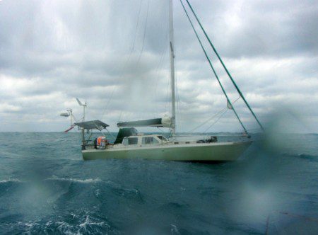
On Saturday, April 29, 2023, US Coast Guard Cutter HAROLD MILLER had to run 60 miles out into the Gulf of Mexico to rescue two persons from a 37-foot sailboat. Conditions were 34 mph winds and 6-8-foot seas. The Coast Guard Vessel Traffic Service in Houston had issued a warning just the day before predicting gale force winds in excess of 30 knots.
Coast Guard Sector Houston-Galveston watchstanders also received a relayed 911 call at 3:50 p.m. reporting a 20-year-old male surfer being pushed offshore in 8-foot seas and winds of 34 mph. The surfer’s father had donned a life jacket, tied a fishing line to his belt, and was having difficulty swimming out to help his son. Watchstanders issued an urgent marine information broadcast and diverted an already-airborne MH-65 Dolphin helicopter crew from Coast Guard Air Station Houston to assist. The helicopter crew arrived on scene, hoisted the surfer, and brought him to the beach. A family member on the beach reeled the surfer’s father safely ashore.
Everyone knows the power of water is great. It can cut through steel or fling a recreational boat through the air as if it were nothing. Mariners call the power of water the sea state, and a good working knowledge of sea states is necessary in order to survive on the open sea. Another term for sea state is waves, and that is what most people associate with the sea state, but there is much more to the sea state than waves. Here are a few terms and their definitions so that you will understand what we are talking about.
Terms
- Sea State: In oceanography, Sea state is the general condition of the surface of a large body of water- with respect to wind, waves and swell- at a certain location and moment. Sea state is characterized by wave height, wave period, and power spectrum.
- Wave Height: Wave height is the difference between the wave crest (top of the wave) and the neighboring trough (bottom of the wave). Wave height is further broken down by most frequent waves, significant waves, and maximum waves.
- Most Frequent Waves: Most frequent waves are about half the height of significant waves. They represent about two thirds of the waves seen in a particular area and are about half the height of significant waves.
- Significant Waves: Significant waves are the highest third of the waves in a particular area. If you hear that the waves are “three to five feet,” that means the most frequent waves are three feet high, and the significant waves are five feet high.
- Maximum Waves: Maximum waves are usually twice the height of significant waves but are infrequently seen (average three times per 24-hour period). Those are the ones that sneak up on you. You might hear someone say the waves are “three to five feet, occasionally up to ten feet.” That is the range of waves from most frequent, to significant, to maximum waves.
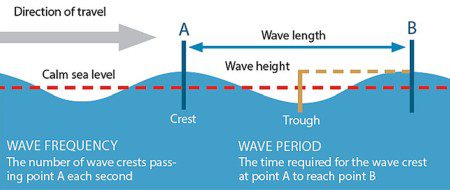
- Wave Period: Wave period is the distance between two waves passing through a stationary point, measured in seconds. Another way to put it is wave period is the amount of time it takes for a wave crest to travel one wavelength.
- Wave Length: Wave length is the distance between two crests measured in feet. Shorter wave lengths also tend to be shorter in height.
- Ocean Swells: Ocean swells are ocean waves that move beyond the place where they were generated. Ocean swells can travel great distances and inevitably encounter other swells of different lengths and heights and traveling in different directions. A typical sea state is made up of a mixture of deep-water swells and waves, which all combine to form the chaotic ocean surface known as the wave spectrum.
- Wave Power Spectrum: The energy in waves comes from the movement of the ocean and the changing heights and speed of the swells. An average 4-foot wave striking the coast puts out more than 35,000 horsepower per mile of coast. Waves get their energy from the wind, and the wind comes from solar energy. As long as the sun shines, wave energy will never be depleted.
- Combined Seas: Wind waves are independent of the swell and add to the wave height. The result is called the combined seas. The National Weather Service considers the combined seas equal to the significant wave height.
- Wind Fetch: Wind fetch is the length of water over which a given wind has blown without obstruction. In the open ocean, a fetch can be a thousand miles or more in length.
Ocean Wave Development
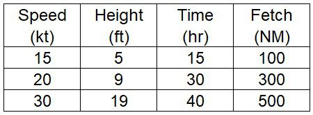
Waves develop from the wind blowing across the water’s surface for a certain amount of time over a certain distance (the fetch). When the waves in a fetch move to another location they become a swell. There are a number of things that can change the shape, height and direction of a swell. Reflection happens when waves bounce off an obstruction and combine with still approaching waves. Refraction is a change in direction as a wave encounters shallower water near the shore. The shallower water slows the wave, causing a bending (refraction) that tends to cause parallel wave fronts to approach the shoreline. When currents oppose the wind, waves can increase to steep and dangerous heights. Below is a table that illustrates some combinations of speed, time and fetch required to produce a certain wave height.
Breakers
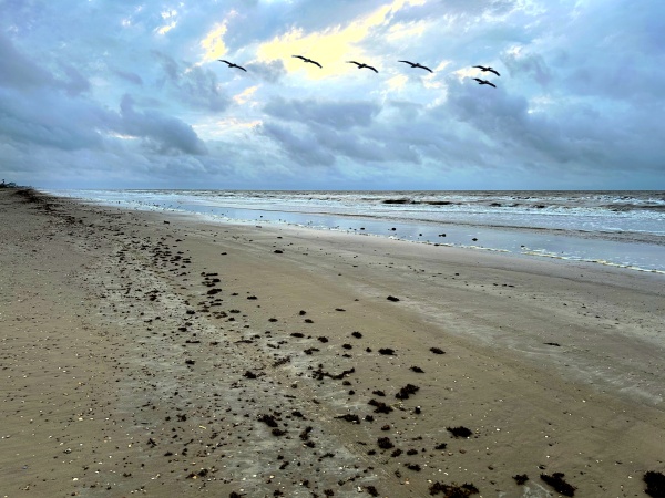
Swells become breakers as they move into the shallow water surf zone. Waves are supported by orbital currents called eddies beneath the wave. As the swell approaches the shore the eddies flatten as the water becomes shallower. The eddies are flattened and tilted upward toward the shore. The shoreward side of the swell becomes steeper and crests, thus forming breakers. I have watched as three-foot breakers tore a 35-foot motor sailer to pieces. Those three foot waves had the power of the Gulf of Mexico behind them, and with the boat stuck on the third sand bar those waves made short work of the boat as they pounded it to pieces. Luckily no one was aboard. This is a very good reason to avoid the surf zone with your boat.
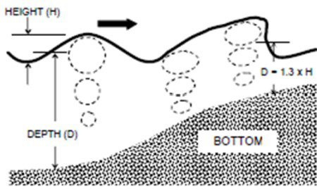 Breaker Formation
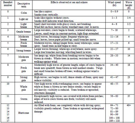
The original Beaufort Scale divided sea states into 12 categories, based on the amount of sail a British frigate could carry. An observer may estimate the sea state category based on the visual appearance of the sea surface.
Sea State Implications for Recreational Boaters
It is up to you to determine the maximum sea state that your boat could handle, and then to make sure you don’t end up trying to sail in a sea state that is beyond the capabilities of your boat and your crew. In order to understand the sea state concept, you must learn the terminology used by weather forecasters. If the weather report says seas are 3-5 feet, then you must understand that although most waves are three feet high, a third of the waves can be five feet high (significant waves), and occasionally there will be waves as high as 10 feet. If your boat can’t handle a ten-foot wave, then you should not be out when the report is 3-5 foot seas. While you might be able to handle 10-foot seas that have a long wave period, much shorter waves with a short wave period can be deadly.
If all you know is the wind speed, you can still estimate the sea state by using the Beaufort Scale. Beware of changing sea states due to other swells moving into your area. If the wind changes, observe for a changing sea state. Plan an alternate route to shore or a second safe harbor if you are caught unaware by a changing sea state.
Summary
Knowledge of sea states, how they are formed, and how they affect wave formation can save you from being caught in a sea state that your boat (or surfboard) can’t handle. Know the capabilities of your boat and do not go out when the forecasted sea state is more than you can handle. Pay attention to those weather forecasts.
[BC: May-2-2023]
 Posted in