 By Bob Currie, Recreational Boating Safety Specialist
U. S. Coast Guard Auxiliary Station Galveston Flotilla
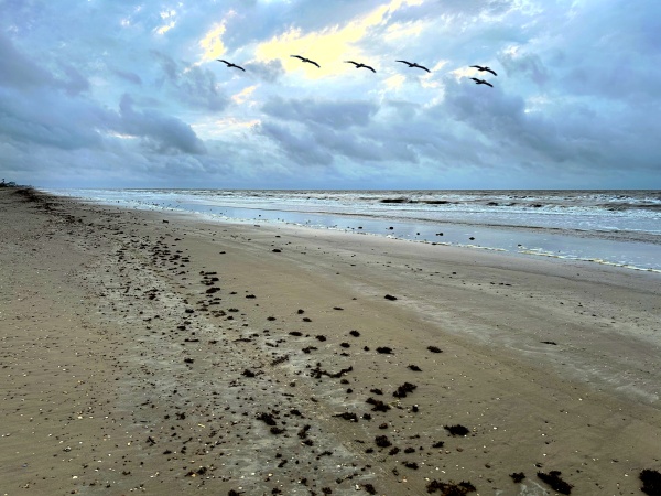
As a recreational boater, if you have operated your boat along the shore, in the ship channel, or within the Intracoastal Waterway, you have encountered a myriad of floating buoys and fixed structures with various colors, shapes and signs. You may know that these objects in and near the water are used the same way traffic signs and lights are used to guide and direct cars on roads and highways, but many recreational boaters do not have a complete grasp of how the system works for vessels on the water. This column will give you a brief overview of what is called the U.S. Aids to Navigation (ATON for short, and pronounced aye ton), and will emphasize the Preferred Channel Marker. The Preferred Channel Marker marks Junctions (splits in the main channel).
The Station Galveston Flotilla of the US Coast Guard Auxiliary operates out of the USCG Station Galveston base on Galveston Island. They aid the Coast Guard by providing maritime observation patrols in Galveston Bay; by providing recreational boating vessel safety checks; and by working alongside Coast Guard members in maritime accident investigation, small boat training, providing a safety zone, Aids to Navigation verification, in the galley, and watch standing.
Red, Right, Returning: ATONs Mark the Way
There are two basic types of ATONs. ATONs are either Lateral ATONs or Non-Lateral ATONs. Lateral ATONs are used to mark the preferred route to follow for well-defined channels. They are part of the short-range system for navigating waterways called the U.S. Lateral System, or the U.S. Aids to Navigation System. In the U.S, short-range aids conform to the International Association of Lighthouse Authorities (IALA) Region B, otherwise known as System B. Most of Europe and Asia use System A. The main difference between the two systems is that our system, System B, uses the color red for buoys and beacons on the right side of the channel when viewed returning from sea (with green on the left), while System A uses green on the right and red on the left when returning from sea. Since all channels do not lead from seaward, certain assumptions must be made so the system can be consistently applied. In the absence of a route leading from seaward, the conventional direction of buoyage generally follows a clockwise direction around land masses.
Under IALA-B, the memory aid 3R rule (red, right, returning) applies when a vessel is returning from seaward. If you want to sound nautical the next time you ride the ferry and pass a buoy that is completely red in color, just say “Red, right, returning,” and your deckhand will surely take you for a mariner.
If You Get to a Fork in the Road, Take It
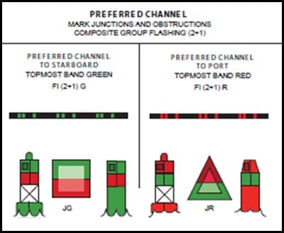
Every time I encounter a Preferred Channel Marker I am reminded of the Yogi Barra saying about forks in the road. The diagram below illustrates the various daytime buoys and beacons used for navigation one may encounter in our area. The beacon or buoy that you will find at a junction, otherwise known as a fork in the road or channel, is shown in the diagram below just above the fork. The proper name of the ATON is Preferred Channel Marker. You find a Preferred Channel Marker marking a split in the main channel when you are returning from sea; when the main channel splits, it is called a Bifurcation. When two channels come together, it is called a Junction. In the diagram below the Preferred Channel Marker is a can with a red band on top and a green band below the red band. It also has a red light on top.
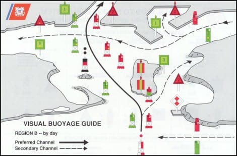
The top-most color indicates the direction of the preferred, or primary channel. When returning (entering a channel from the open sea or proceeding upstream), keeping the ATON with red as the top-most color on the right (starboard) side of the boat will place the boater in the preferred channel, while keeping those ATONs on the port side will place the boater in the secondary channel. If the top band is red, the ATON will be either a nun buoy or a triangular daybeacon. If the top band is green, the ATON will be either a square daybeacon or a can buoy. Red triangle or red light: go left; green square or green light: go right.
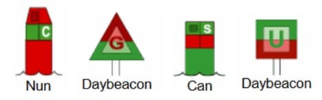
Preferred channel ATONs will have letters instead of the numbers found on the lateral system markers. White letters are found on nuns and cans, while the letters will be either green on square daybeacons or red on triangular daybeacons. Reminder: the preferred channel marker routes given above apply when returning from sea (aka the conventional direction of buoyage). If approached from the opposite direction, then reverse the side on which to keep the marker if you wish to remain in the main channel; that is, red triangle or red light: go left; green square or green light: go right.
Operation at Night
If you have ever operated in an area where there are many ATONs, then you should know that operating in that area at night is an entirely different proposition. The different lighted ATONs may be distinguished by a combination of the color of the light and the flashing sequence of the light. The diagram below indicates the colors and flashing sequences you may encounter on the water. A dot represents a quick flash, and a dash represents a long flash while the length of the pause between flashes is directly related to the amount of black between the flashes on the diagram. Channel marker lights will always be either green or red; the white lights are not navigational lights but indicate other things such as the Safe Channel Marker at the very bottom and center of the diagram.
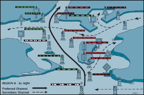
Preferred Channel Markers use a Composite Group Flashing (2+1) signal as indicated below. Remember this flashing sequence and follow the color rule to stay in the preferred channel. What- you forgot it already? Don’t scroll up. Here it is: Red triangle or red light: go left; green square or green light: go right.
Summary
Recreational boaters operating within an area where there are navigational buoys and daybeacons can become confused if they don’t have a working knowledge of the various Aids to Navigation used. One of the hardest ATONs to grasp and remember is the Preferred Channel Marker. If you don’t learn the rule, you may find yourself in the wrong channel.
For more information on boating safety, please visit the Official Website of the U.S. Coast Guard’s Boating Safety Division at www.uscgboating.org. Questions about the US Coast Guard Auxiliary or our free Vessel Safety Check program may be directed to me at [email protected]. SAFE BOATING!
[June-15-2020]
 Posted in