 By Bob Currie, Recreational Boating Safety Specialist
U. S. Coast Guard Auxiliary Station Galveston Flotilla
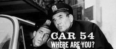
The title of this column alludes to the 1960s TV sitcom “Car 54 Where Are You!” Car 54 starring Joe E. Ross and Fred Gwynn as New York City policemen. Al Lewis was a supporting actor. Fred and Al would later be known for their portrayals of Herman Munster and Grandpa on “The Munsters.” So, what the heck does this have to do with recreational boating safety? It’s about emergency communication with the Coast Guard. Officers Toody (Ross) and Muldoon (Gwynn) were always having communication trouble, just as boaters in distress often have communication trouble.
The Station Galveston Flotilla of the US Coast Guard Auxiliary operates out of the USCG Station Galveston base on Galveston Island. They aid the Coast Guard by providing maritime observation patrols in Galveston Bay; by providing recreational boating vessel safety checks; and by working alongside Coast Guard members in maritime accident investigation, small boat training, providing a safety zone, Aids to Navigation verification, in the galley, on the Coast Guard Drone Team and watch standing.
The i911 System
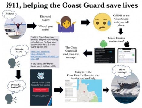
The Coast Guard has a new system for locating boaters in distress. It is called i911. The i911 system uses cell phone location systems to locate boaters. i911 is not a replacement for standard marine devices such as Electronic Position Indicating Radio Beacons (EPIRB) and VHF radios but an additional tool to provide potentially lifesaving information from a mariner’s cell phone. The system has a similar range as the Coast Guard’s Rescue 21 System: about 20 miles. The i911 system is a free service developed by Callyo Incorporated. It provides fast and accurate location data to the Coast Guard in a simple web-based interface. The user’s smartphone can provide Global Positioning System information, potentially up to 20-nautical miles offshore if a mariner has recently or actively connected to a cellular tower. An accurate position eliminates the need to search and decreases the time needed for rescuers to get on scene to provide needed assistance.
The Coast Guard is not actively monitoring all individuals by their cell phone and only has access to a person’s position if granted permission. No application download is needed. The Coast Guard can send a text message to the mariner’s cell phone requesting permission to access the GPS location information; all the mariner needs to do is enable location information in their smartphone settings and click the link provided in the text message. You can stop sharing your location at any time, although it is recommended to do so only after being safe and not in distress. i911 pairs consumer smartphone technology with a web-based interface that Coast Guard command centers can use to locate distressed mariners. The technology uses the internal GPS of a cellphone to send the mariner’s location to a web-based map accessed by command center personnel. Its accuracy is often within a range of one to three meters.
Here is a graphic representation of how the system works:
What it Looks Like on Your Cell Phone
Here is another graphic representation of how the system works:
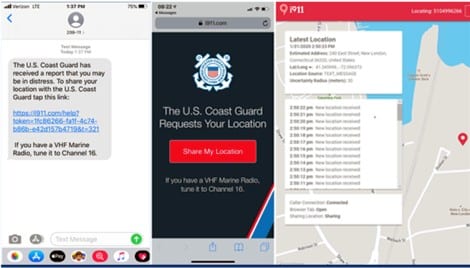
At left, a screenshot of the text message a boater in distress will receive from the U.S. Coast Guard. When the boater taps the link in the message, they are directed to the i911 site (middle), where they are asked to share their location. Once the boater taps the share button, i911 is able to pinpoint their location with an area of uncertainty of 1 to 3 meters (command center view at right). The tool requires no registration or downloading of mobile applications. U.S. Coast Guard graphic.
Summary
Although the best method of being located by the Coast Guard when you find yourself in need of help within 20 miles of shore is the combination of a marine VHF/FM radio and the Coast Guard Rescue 21 system, the Coast Guard is rolling out a new system that uses cell phone technology to help locate boaters in distress. The i911 system also has a range of about 20 miles from shore, and it has been used quite successfully in the test areas. When it is fully implemented it will give us another cost effective way of rescuing boaters in distress. Once the system is rolled out in our area, I will give detailed instructions on how to use the system, but one of the most important things you can do is turn on your cell phone location service. That is what the system uses to locate you.
For more information on boating safety, please visit the Official Website of the U.S. Coast Guard’s Boating Safety Division at www.uscgboating.org. Questions about the US Coast Guard Auxiliary or our free Vessel Safety Check program may be directed to me at [email protected]. SAFE BOATING!
[September-7-2020]
 Posted in