 By Bob Currie, Recreational Boating Safety Specialist
U. S. Coast Guard Auxiliary Station Galveston Flotilla
Beginning this month or early next, Aids to Navigation (ATONs) along the Houston Ship Channel (HSC) will be actively changing as dredging will commence that will widen the HSC along the Galveston Bay reach (Bolivar Roads to Morgan’s Point) and deepen and widen the channel along various reaches from Morgan’s Point to the Turning Basin. This project is known as “Project 11” and is projected to be completed sometime in 2025.
The Station Galveston Flotilla of the US Coast Guard Auxiliary operates out of the USCG Station Galveston base on Galveston Island. They aid the Coast Guard by providing maritime observation patrols in Galveston Bay; by providing recreational boating vessel safety checks; and by working alongside Coast Guard members in maritime accident investigation, small boat training, providing a safety zone, Aids to Navigation verification, cooking in the galley, on the Coast Guard Drone Team and watch standing.
The following offers a summary of:
- Project 11,
- Types of Dredges that will be utilized, and
- AIS ATONs which will be used extensively to mark the areas while dredging is on-going
Project 11
Expanding the Houston Ship Channel is critical to safely and efficiently sustaining national energy security, domestic manufacturing growth, thriving U.S. exports, and expanding job opportunities.
The Houston Ship Channel is one of the most vital waterways in the country, connecting the nation’s largest petrochemical complex to the world. Currently, annual activity on the waterway includes more deep-draft ship arrivals and departures than any other port in the country. At the same time, nearly 200,000 barge transits are moving coastwise to and from Houston as well as within the port itself.
As energy and manufacturing exports increase, larger ships are calling at the port. Improving the capability to accommodate these larger vessels that are arriving in ever-increasing numbers has become a national priority. This has resulted in moving forward with widening, and in certain sections, deepening the HSC.
When complete, the Houston Ship Channel Expansion – Project 11 – will widen the channel by 170 feet along the Galveston Bay reach, from 530 feet to 700 feet. It will also deepen some upstream segments to 46.5 feet, make other safety and efficiency improvements, as well as craft new environmental features.
Widening and deepening the Houston Ship Channel will:
- Accommodate the larger ships that can now transit the recently widened and deepened Panama Canal
- Reinstitute two-way traffic when the larger ships are transiting the ship channel
- Smoothing bends in the channel will also improve safety
DREDGING ACTIVITY
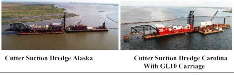
Dredge Vessels – Required Lights and Shapes
To recognize a dredge, navigation rules require certain day shapes to be exhibited and certain light configurations at night or in restricted visibility. These characteristics are required whether the dredge is conducting operations or underway.
Vessel Restricted in Its Ability to Maneuver – Day Shapes

Vessel Restricted in Its Ability to Maneuver – Night Lights
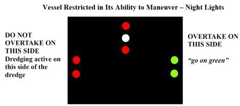
When a dredge is underway, navigation lights and masthead lights are also required.
Additionally, if a pipeline that is floating or supported on trestles that is connected to the dredge as a mechanism to move the dredged material to a scow or to a nearby remediation location, lights are required along the pipeline at night and in periods of restricted visibility to mark its location. (See Rule 27 of the Navigation Rules for details).
Automatic Identification System (AIS) ATONs
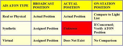
As dredging proceeds, ATONs will be either removed or relocated outside the boundary where dredging will occur. Those ATONs removed or relocated will be supported by the installation of AIS ATONs, which may be activated prior to the removal or relocation of the existing ATONs. As a result, all three types of AIS ATONs may be in play at various times along the HSC. Specifically:
- Real AIS ATON – A physical aid to navigation structure exists on which an AIS transmitter is affixed and from which AIS messages are broadcast.
- Synthetic AIS ATON – A physical aid to navigation structure exists, without an AIS transmitter, but for which AIS messages are broadcast from another location; usually land-based.
- Virtual AIS ATON – An aid to navigation with no physical structure. It exists only through AIS messages broadcast from another location; usually land based.
AIS ATONs broadcasts information using AIS technology. To utilize this AIS technology requires the installation of a Class B transponder necessary to receive the AIS ATON message, decode the data, and plot the AIS ATON on a chart plotter. Other ancillary equipment, such as a splitter and a GPS antenna may also be required to complete the installation.
Mechanics of AIS Transmissions
- If the AIS ATON is broadcasting the signal for a real ATON, the AIS transmitter is affixed to the ATON and the position being broadcast by the AIS signal will always correspond to the ATON’s actual location. Compare the assigned position stated in the light list to the actual location being broadcast to determine if the ATON is on or off station.
- If the AIS ATON is broadcasting the signal for a synthetic AIS ATON, the AIS transmitter is not affixed to the physical ATON and therefore the location being broadcast by the AIS signal will always correspond to the ATON’s assigned position. Therefore, the actual position of the ATON is “unknown,” and this creates a potential “DANGER” situation requiring a proactive response. It is essential to compare the actual location of the ATON with the broadcast assigned position to determine if the ATON is on or off station and is marking “good water.”
- If the AIS ATON is a virtual AIS ATON, it will always appear as being on its assigned position, because the physical aid does not really exist.
These situations are summarized by the table below:
Existing AIS ATONs
Within the Galveston Bay AOR, there are three (3) AIS ATONs and all three broadcast MMSI information.
Two AIS ATONs are Synthetic. That is, a physical ATON exists, but the AIS transmitter is not affixed to the ATON; its location is elsewhere. These two ATONs are:
-Galveston Bay Entrance Safe Water Mark (LLNR 23680) located offshore-
-Bolivar Roads Anchorage Lighted Buoy “B” (LLNR 23805)-
The third AIS ATON, Bolivar Roads Anchorage A (LLNR 23800), is a virtual AIS ATON.
Summary
If you travel or cross the Houston Ship Channel, be on the lookout for dredging operations. Be aware that Aids to Navigation buoys will be removed or relocated during these operations.
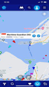
Marine Traffic Screenshot from my Cell Phone
If you do not have AIS installed on your boat, consider installing it if you plan to frequently navigate the waters being dredged. Another way to passively view AIS data is via your smartphone using an app such as Marine Traffic, Boat Beacon, or Ship Finder. These apps are available for a very small cost ($3.99 to $12.99). Some DSC enabled marine radios also have passive AIS.
If you are operating in an area where dredging is occurring or even if the dredges are merely anchored, slow down, be very alert for dredging pipes just below the surface, and if you hear the danger signal (5 short blasts), stop and assess the situation, as the signal may be a warning for you. Listen on channel 13 while operating in the Houston Ship Channel. This is the bridge-to-bridge channel.
For more information on boating safety, please visit the Official Website of the U.S. Coast Guard’s Boating Safety Division at www.uscgboating.org. Questions about the US Coast Guard Auxiliary or our free Vessel Safety Check program may be directed to me at [email protected]. SAFE BOATING!
[Mar-15-2022]
 Posted in