On The Peninsula

High Island

11-HighIsland
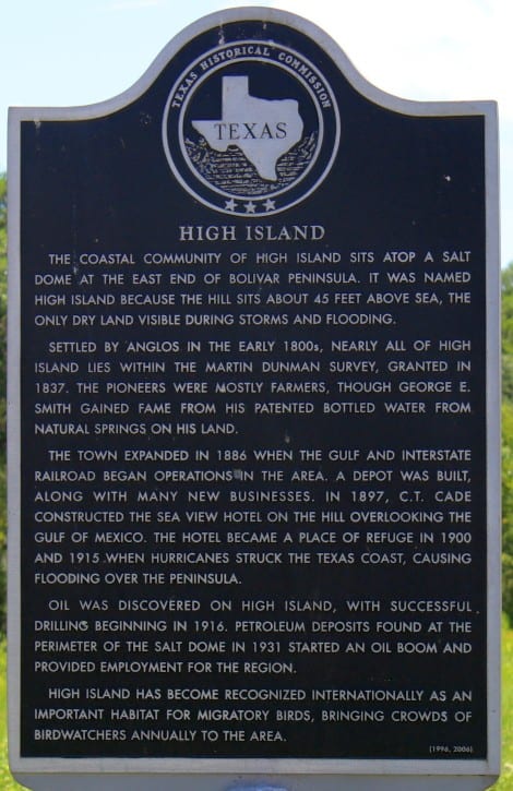
The coastal community of High Island sits atop a salt dome at the east end of Bolivar Peninsula. It was named High Island because the hill sits about 45 feet above sea, the only dry land visible during storms and flooding.

Settled by Anglos in the early 1800s, nearly all of High Island lies within the Martin Dunman Survey, granted in 1837. The pioneers were mostly farmers, though George E. Smith gained fame from his patented bottled water from natural springs on his land.

The town expanded in 1886 when the Gulf and Interstate Railroad began operations in the area. A depot was built, along with many new businesses. In 1897 C. T. Cade constructed the Sea View Hotel on the hill overlooking the Gulf of Mexico. The hotel became a place of refuge in 1900 and 1915 when hurricanes struck the Texas Coast, causing flooding over the peninsula.

Oil was discovered on High Island, with successful drilling beginning in 1916. Petroleum deposits found at the perimeter of the salt dome in 1931 started an oil boom, and provided employment for the region.

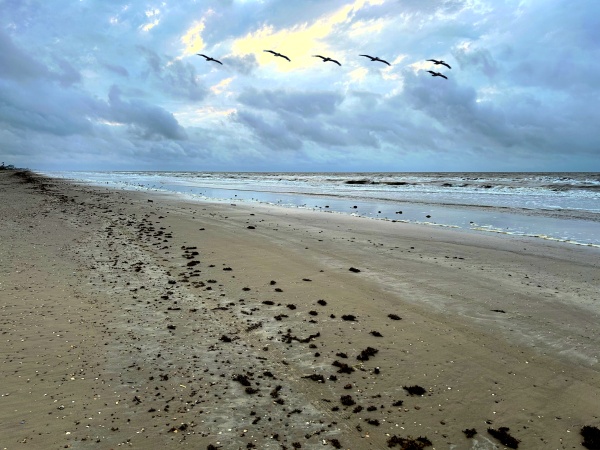
High Island has become recognized internationally as an important habitat for migratory birds, bringing crowds of bird-watchers annually to the area.

Charles Cronea

10-CharlesCronea
(January 14, 1805 – March 4, 1893)
Born in Marseilles, France, Charles Cronea came to America on a French frigate as a cabin boy in 1818. Soon after, boarding a ship out of Charleston, South Carolina, Cronea and several companions entered the service of Jean Laffite of Galveston engaged in privateering cruises off the coast of Spanish Mexico. After nearly a year under the command of Capt. James Campbell., he left the ship when it was burned at the mouth of the Mermentau River in Louisiana.

Cronea married Amanda Richey in 1830. By 1835 he had settled in the Mexican Municipality of Jefferson. The Texas Revolution broke out that Fall. Cronea joined Capt. David Garner’s Company of frontier farmers and participated in the siege of Bexar. Some records say Cronea’s company joined with the forces of Sam Houston in 1836, and that during the battle of San Jacinto, Cronea was guarding prisoners nearby. In 1846 he entered the U.S. Army in the war against Mexico under Gen. Zachary Taylor.

Later a farmer in Sabine Pass, Cronea married Mary Louisa Elender in 1845. They moved their family to High Island in 1876. Cronea was awarded 1,280 acres as a surviving soldier of the Texas Revolution in 1885. Cronea is buried in this cemetery. (1996)

Rollover Fish Pass

12-Rollover-old
A strait approximately 200 feet wide, 5 feet deep and more than 1,600 feet long across Bolivar Peninsula – was opened in 1955 by the Texas Game and Fish Commission as part of its continuing program to perpetuate and improve the state’s fish and wildlife resources.

The commission’s purposes in constructing this pass were to introduce into East Bay sufficient quantities of sea water to increase bay water salinity, and to provide additional opportunity for travel of marine fish to and from spawning and feeding areas in the bay.

Lower salinity in East Bay was caused by the discharge of several fresh water streams into the area on the mainland side of the peninsula. This excessive fresh water not only limited the existence of marine fish but also restricted the growth of submerged vegetation, which provides nursery areas and forms the basis of the food cycle for marine life.

The marker was damagedin Hurricane Ike

The marker was damaged
in Hurricane Ike

Creation of Rollover Fish Pass has greatly improved salt water fishing conditions for the thousands of sportsmen who flock to East Bay throughout the year.Known as Rollover long before the Texas Game and fish Commission constructed the fish pass, this site has a history steeped in legend dating back to the days of the Spaniards and continuing through the American prohibition period.

According to legend, it was first called Rollover because certain early ship captains preferring to avoid contact with the customs station at Galveston would roll barrels of imorted merchandise from the gulf side of Bolivar Peninsula over to East Bay. From there the barrels were transferred to the mainland without further formality.

The same rolling procedure – in reverse – also is said to have been used for selected items of export.

The Breakers

8-TheBreakers
Terrence Meche, a Ships Carpenter, built this beach house in 1884, using materials shipped in from Pensacola, Florida. Although the house withstood the devastating 1900 Storm, Meche and his family abandoned it. William D. and Ruth McLean Gordon purchased the house in 1905 and named it the “Breakers”. Used as a vacation home by the Gordon Family for many years, the Breakers underwent a number of alterations including relocation to higher ground. It survived the 1915 Hurricane and subsequent gulf storms, and has become a noted local landmark. (1990)
(The Breakers was destroyed in Hurricane Ike. The original marker was recently re-installed on the property.)

Crenshaw Family Cemetery

7-CrenshawCemetery
Virginia Native and Civil War Veteran James A. Crenshaw wed Henrietta Barker Elliott in Kentucky in 1870. Two years later, with their first child, they moved to Bolivar Peninsula and constructed a two-story house in this vicinity. James, a successful farmer, transported his produce across the water to Galveston markets using his fleet of nine sailboats. The couple eventually had ten children; two young daughters died, one in 1875, the other in 1882, and the family buried them here in a grove of oak trees close to the house.

The family’s home survived the 1900 Galveston hurricane; after the storm, the J.A. Crenshaws left the Peninsula. Two sons remained, and daughter Helen Crenshaw wed Dr. Newell W. Atkinson in Edna, Texas, in 1907. The land containing the burial ground remained in family hands, but the iron fencing around the cemetery gradually disappeared except for a portion imbedded in a tree. In 2003, two descendants of Helen and Newell Atkinson donated land, including the burial ground, to the Galveston Independent School District, which maintains the historic cemetery as a link to early Bolivar settlers.

Port Bolivar Cemetery

6-PortBolivarCemetery
Port Bolivar Cemetery was established between 1885 and 1890. There was seven recorded graves before 1900. They were the descendants of the Simpton’s, Schreiber’s, Clinton’s and Megg’s. In the early 1900 the recorded family graves are Johnson’s, Lindner’s, Langham and Shaw. There are dome unknown names for grave site located in the cemetery. In 1994 Jane Ewing located and record all graves. 1972 1.76 acres and in 1994 1.33 acres was donated by the Jeffery Family. In 2011 the Andrew Johnson Family donated 0.36 acres. The cemetery is free of charge for the residents of Port Bolivar and their families. The cemetery is maintained by donations and volunteers. For more information website search Find a Grave Port Bolivar Cemetery.

Port Bolivar

5-PortBolivar
Surveyor Samuel D. Parr claimed a league of land extending 5 miles eastward from Point Bolivar and in 1838 became the area’s first permanent settler. That year developers Archibald Wynn and William Lawrence purchased about 1000 acres of Parr’s land and surveyed a townsite named Ismail (Ishmael). When the first post office was established in 1876 the community’s name became Gabion. The community was renamed Port Bolivar in 1893.

In 1896 developers L.P. Featherstone and Fox Winnie constructed a railroad line connecting Point Bolivar to Galveston and Beaumont. Featherstone was instrumental in dredging a channel and building a wharf, where the first cargo ship landed in 1909. The town prospered and by 1911 contained a schoolhouse and a Methodist church. Business activity at the wharf continued to expand and Port Bolivar’s economy surged.

Shipping worldwide slowed at the outset of World War I and use of the wharf declined. In 1915 the town and wharf were severely damaged by a storm and many facilities were never rebuilt. The community turned to commercial fishing and tourism to successfully revitalize its economy. Regular ferry service to the mainland, which began in 1930, continues today.

Jane Herbert Wilkinson Long

3-JaneLong
(July 23, 1798 – December 30, 1880)
Born in Charles county, Maryland, Jane Herbert Wilkinson Long was a Texas pioneer. She married James Long in 1815, and joined him in Texas during his military invasion of the then-Spanish colony, settling in Nacogdoches. The occupation was unsuccessful, but the Longs returned with supporters in 1820, building a fort on the Bolivar peninsula at the eastern entrance to Galveston bay. James Long left for La Bahía to gain support, but was captured and imprisoned in Monterrey. Meanwhile, Jane, along with her daughter Ann and slave Kian, remained at the fort, facing frigid winter temperatures, lack of food and supplies, and danger from the native Karankawas. In the midst of these difficulties, Jane Long gave birth to a child, leading to her honorary designation as “Mother of Texas.”

After hearing of her husband’s death, Long led her family to settle at various places along the San Jacinto river and San Antonio. The family moved to be with kin in Louisiana and Mississippi in 1823, but returned in 1825 as part of Stephen F. Austin’s first colony, receiving her own headright of land, usually accorded only to a male head of household. She settled in San Felipe de Austin.

During the Texas war for independence, Long opened her boarding house for rallies and meetings, while also gathering information from Mexican officers and storing arms and munitions. She fled with others during the runaway scrape. After the war, in her remaining years, Long operated a boarding house and plantation in Fort Bend county. Today, Jane Herbert Wilkinson Long continues to be remembered as a Texas patriot and a pioneer of the Texas frontier.

Bolivar Point

2-BolivarPoint
In 1815 Colonel Henry Perry established a military camp here as part of a plan to invade Spanish Texas. In 1816 Galveston-based privateer Louis-Michel de Aury forced shiploads of captured African Slaves to walk from this point to New Orleans along old Indian Trails. Aury is credited with naming the point after South American liberator Simon Bolivar.

While commanding a filibuster to win Texas independence, James Long established Fort Las Casas on Bolivar Point in 1820-21. His wife, Jane Herbert (Wilkinson), gave birth to a daughter, Mary James, in December 1821 at the fort. Mary James Long is often referred to as the first Anglo child born in Texas.

A lighthouse, erected here by the Federal government in 1852 and later dismantled by Confederate soldiers during the Civil War, was rebuilt after the war. Many area residents sought shelter within the lighthouse during the damaging storms of 1900 and 1915.

The Gulf and Interstate Railroad was completed from Beaumont to Bolivar Point in 1896. A boon to peninsula farmers, the railroad was destroyed in the 1900 storm, then rebuilt in 1903. Ferry service, purchased by the Texas Highway Department in 1933, continues to provide free public access to Galveston Island.

Fort Travis

4-FortTravis
In early 1836, soon after Texas declared independence from Mexico, Republic of Texas President David Burnet dispatched Colonel Ed Harcourt to Galveston Island to erect a fort. Using army recruits and slave labor Harcourt built an octagonal earth and timber fortification armed with six and twelve-pound gun mounts appropriated from the Texas Navy vessel CAYUGA. Named Fort Travis in honor of William B. Travis, famous defender of the Alamo, it was located at the east end of the island. After high winds damaged the fort in 1837 the site was converted into a gun battery called Fort point, its present name.

In 1898-99, with the beginning of Federal development of the Port of Galveston, a second Fort Travis was established across Galveston Bay at Bolivar Point near the former site of a Civil War Confederate fortification called Fort Green. Two batteries, named Davis and Ernst, were completed in 1899 and a third, named Kimble, completed in 1922. Coastal defense facilities were added to the fort during World Wars I and II. Fort Travis was decommissioned and sold as war surplus in 1949. Besides its obvious military uses, Fort Travis also served as a refuge from hurricanes and as a Civil Defense shelter for area residents.

Point Bolivar

1-PointBolivar
Headquarters for Long’s expedition which attempted to free Texas from Spanish rule in 1819. Named in honor of Simon Bolivar (1783-1830) leader in the Spanish-American War for independence. Here Mrs. Long and a small group remained until news of her husband’s death came in 1822. A lighthouse was erected here by the Republic of Texas.

Big Ships

ships_0
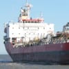
We see them all over, especially when riding the Bolivar Ferry. Ever wonder where they’ve been or where they’re going? Or what they may be carrying? With a couple clicks, you can find out. Next time you’re riding the ferry, snap a photo or write down the name of the ships you see along the way. Then go to www.vesselfinder.com and type in the Ship Name in the search box. Click on the official name

Lone Survivor Retreat Dedication

LS00On Saturday, April 25, the ribbon was cut to officially open and dedicate the Lone Survivor Crystal Beach Retreat Facility. After nearly a year of construction, the facility is complete and the Foundation is ready to begin retreats.

Who IS that guy?

By Cindy Clay Srader
If anyone was on the Peninsula this past weekend, you might have seen this good looking guy with his trademark dreadlocks. Or maybe you watched American Idol a few seasons ago when he came in third place. His name is Jason Castro and he and his family were vacationing on our beach with his beautiful wife Mandy and their

Rollover Pass Litigation

For Immediate Release
April 19, 2013
The Gulf Coast Rod, Reel and Gun Club and the Gilchrist Community Association filed suit in federal court in Galveston today against Texas Land Commissioner Jerry Patterson and the Corps of Engineers over various actions related to attempts to close Rollover Pass, a popular recreational fishing venue on the Bolivar Peninsula of Galveston County. Among the allegations

Bolivar on the mend

FOX 26 photojournalist Darlene Janik was on Bolivar last Thursday shooting a story about the area’s recovery from Hurricane Ike four years earlier.

CLICK HERE for the story.


Lazy D&D RV Resort opens

We have been watching it since January when the heavy equipment started digging the canals. On the north side of Hwy 87, across from the Golf Course, Lazy D&D RV Resort has been taking shape. David Altemus and his wife Debra are the D&D, but neither of them are lazy. They have been working very hard to turn their piece of undeveloped land into a premier RV resort. With several

Fishing on Bolivar – UPDATE

Below are articles sent by two residents regarding fishing on Bolivar:

The Story of Bluewater Bait Camp

by Nelva Toups Maxey
Curtis and I were looking for property in Crystal Beach just so he could dock his shrimp boat. We found six lots on Gator point which already had a small dock. We bought the property. Two months later, the Chapmans Point property came up for sale. Our realtor knew we were looking for property with a dock and this property happened to be a run down bait camp, just across the Canal from

Birthdays on the Beach

There is nothing like throwing a birthday party at the beach. Everyone will show up. This reporter captured two separate family groups this weekend celebrating birthdays and enjoying the best the beach has to offer. Read on…

Lovely Beach Weddings

Tesa and Kirby reciting their vows

by Carole Hamadey
As the summer approaches, romance blossoms…and Out By The Sea Bed & Breakfast specializes in small, intimate weddings on the beach. Couples delight in marrying with their toes in the sand, birds flying overhead and the waves gently breaking on the shore. Many marry as the day draws to an end and catch the splendid sunsets as

Michael and Brittany wed at beach ceremony

You couldn’t have asked for a more beautiful day. Saturday, Michael (from LaPorte) and Brittany (from Lucerne Valley, CA) tied the knot. This wonderful event was attended by 50+ friends and family. The wedding was held at A Sea Glass Estate, formerly known as Casa Blanca Bed & Breakfast. Pictured is the Groom escorting his Mother, Christy Newman (L) and the Mother of the Bride, Susan Speer. Also pictured,

Looks like a mini bike but rides like the wind

Friday, March 16th, 22 guys and gals from the Down and Dirty 3.5 entered Beaumont. This group has a unique way of biking through your town. It looks like a mini bike but rides like the wind. Saturday, March 17th they rode in the local Nederland parade and then to Crystal Beach for some lunch, then on to Crockett St. for more fun.

Sunday, March 18th, after breakfast they headed to the Bridge Run!!! For those who dared, they drove over

Site by CrystalBeachLocalNews.com