 By Bob Currie, Vessel Examiner
United States Coast Guard Auxiliary Station Galveston Flotilla.
As a recreational boater, if you have operated your boat along the shore, in the ship channel, or within the Intracoastal Waterway, you have encountered a myriad of floating buoys and fixed structures with various colors, shapes and signs. You may know that these objects in and near the water are used the same way traffic signs and lights are used to guide and direct cars on roads and highways, but many recreational boaters do not have a complete grasp of how the system works for vessels on the water.
The Station Galveston Flotilla of the US Coast Guard Auxiliary operates out of the USCG Station Galveston base on Galveston Island. They provide assistance to the Coast Guard by providing maritime observation patrols in Galveston Bay; by providing recreational boating vessel safety checks; and by working alongside Coast Guard members in maritime accident investigation, small boat training, watch standing, and procurement.
This column will give you an overview of what is called the U.S. Aids to Navigation (ATON for short, and pronounced aye ton).
Red, Right, Returning: ATONs Mark the Way
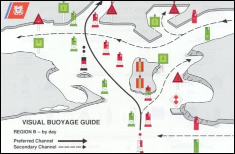
There are two basic types of ATONs. ATONs are either Lateral ATONs or Non-Lateral ATONs. Lateral ATONs are used to mark the preferred route to follow for well defined channels. They are part of the short-range system for navigating waterways called the U.S. Lateral System, or the U.S. Aids to Navigation System. In the U.S, short-range aids conform to the International Association of Lighthouse Authorities (IALA) Region B, otherwise known as System B. Most of Europe and Asia use System A. The main difference between the two systems is that our system, System B, uses the color red for buoys and beacons on the right side of the channel when viewed returning from sea (with green on the left), while System A uses green on the right and red on the left when returning from sea. Since all channels do not lead from seaward, certain assumptions must be made so the system can be consistently applied. In the absence of a route leading from seaward, the conventional direction of buoyage generally follows a clockwise direction around land masses. This column will discuss lateral ATONs. The next column will discuss non-lateral ATONs.
Under IALA-B, the memory aid 3R rule (red, right, returning) applies when a vessel is returning from seaward. If you want to sound nautical the next time you ride the ferry and pass a buoy that is completely red in color, just say “Red, right, returning,” and your deckhand will surely take you for a mariner.
Where ATONs Are Found
ATONs are found in natural channels such as rivers and lakes, and in man-made channels such as our Houston Ship Channel and the Intracoastal Waterway. They are not found in the open sea. The highways at sea, otherwise known as shipping lanes, are for the most part unmarked by ATONs, although they are quite defined on nautical charts. ATONs are used on navigable waterways. Lateral ATONs basically define the portion of a waterway that should allow you to safely operate your vessel. In other words, they mark the deep end of the pool. Non-lateral ATONs provide other information rather than marking the safe route. At one time the Bolivar lighthouse was an ATON. It is no longer used as such, but lighthouses all over the world are part of their respective aids to navigation systems.
Who Maintains ATONs
The U.S. Coast Guard maintains short-range aids to provide:
- Daytime visual system of daymarks, beacons and buoys
- Nighttime visual system of lights and retro reflective signals
- Radar system of radar reflectors and RACONs (radar beacons)
- Sound system of various non-directional sound producing devices, though not required by IALA, such as bells and horns
You may also find private aids on waterways (PATONs). PATONs are maintained by the owner, and are placed in conformance with Coast Guard rules. An example of a PATON is the sign at the entrance to the Blue Water Bait Camp channel, which is used by many fishermen such as me. Besides being maintained, the ATONs and PATONs have their positions and characteristics verified periodically by the Coast Guard (ATONs) or the owner (Coast Guard or owner can verify). ATONs and PATONs often get knocked off station or damaged, and although you must be certified to be able to verify an aid, anyone can report an aid that is missing, damaged, or off station.
LATERAL ATON ESSENTIAL MARKERS
The two main types of ATONs used in the Lateral System are buoys and beacons. A key point for boaters is that it is illegal to tie up to an ATON of any type, whether it is a buoy or a beacon.
Lateral System Buoys
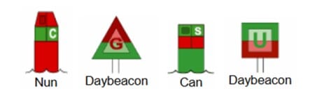
Buoys are aids that float on top of the water, but are moored to the bottom of the body of water. Some buoys have a light affixed to the top; some do not. A buoy with a cylindrical shape with a conical top is referred to as a “nun.” A buoy with a cylindrical shape and a flat top is referred to as a “can.”
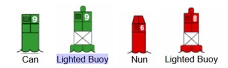
While cans and nuns can also display a combination of colors, the two types shown above are used for marking the sides of navigable channels, and are the most common types of buoys found. We can make a few observations about these lateral marks; first, cans that mark the channel are always green, and if lighted will have a green light, and nuns that mark the channel are always red, and if lighted will have a red light. Both types of markers have numbers that are painted white. Green markers have odd numbers, while red markers have even numbers. Only markers that mark the sides of channels will have numbers. Other markers may only have letters. So, if it is a numbered buoy, it is marking the side of the channel.
Buoys present a hazard that is not found with aids which are fixed. The chain that attaches them to their sinker is long enough to keep the buoy above the surface of the water at high tide. As a result, at low tide the buoy is free to swing about in a circle which could be quite large in diameter. For this reason you should not closely approach a buoy, especially at low tide.
Lateral System Beacons
Beacons are aids that are permanently fixed, most commonly to the bottom of a body of water. They may also be found on dry land. A beacon that has a light attached is simply referred to as a “light”; a beacon without a light is called a “daybeacon.”
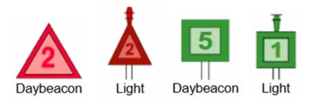
Unlike buoys, which have their numbers and letters painted white, beacons have their numbers and letters painted the same color as the primary color of the beacon. Beacons that are numbered, just like buoys, mark the sides of the channel and provide the safe route. Neither buoy nor beacon numbers represent mile markers, but they are numbered sequentially for a particular route. Red daybeacons are always triangular, with a red light if lighted, while green daybeacons are always square, with a green light if lighted. The same even-odd system used by buoys applies to daybeacons that serve as lateral markers, that is, those markers that mark the sides of the navigable part of the channel.
Preferred Channel ATONs
Beacons and buoys that have horizontal bands of both red and green mark the junction of navigable channels. The top-most color indicates the direction of the preferred, or primary channel. When returning (entering a channel from the open sea or proceeding upstream), keeping the ATON with red as the top-most color on the right (starboard) side of the boat will place the boater in the preferred channel, while keeping those ATONs on the port side will place the boater in the secondary channel. If the top band is red, the ATON will be either a nun buoy or a triangular daybeacon. If the top band is green, the ATON will be either a square daybeacon or a can buoy. Red triangle or red light: go left; green square or green light: go right.
Preferred channel ATONs will have letters instead of the numbers found on the lateral system markers. The same system of coloring the letters applies, though. White letters are found on nuns and cans, while the letters will be either green on square daybeacons or red on triangular daybeacons. Reminder: the preferred channel marker routes given above apply when returning from sea (aka the conventional direction of buoyage). If approached from the opposite direction, then reverse the side on which to keep the marker if you wish to remain in the main channel; that is, red triangle or red light: go left; green square or green light: go right. Help Mr. Wizard!
Light Colors
As noted above, buoys and daybeacons can be lighted or non-lighted. Only ATONs with green or red lights have lateral significance; that is, they are the only light colors that mark the navigable portion of the channel. When proceeding in the conventional direction of buoyage (red, right, returning), the mariner in ILA Region B may see the following lighted ATONs:
- Green lights on ATONs mark port sides of channels and locations of wrecks or obstructions that must be passed by keeping these lighted ATONs on the port side of the vessel. Green lights are also used on preferred channel marks where the preferred channel is to starboard (right).
- Red lights on ATONs makr the starboard sides of channels and locations of wrecks or obstructions that must be passed by keeping these lighted ATONs on the starboard side of the vessel. Red lights are also used on preferred channel marks where the preferred channel is to port (left).
- White and yellow lights have no lateral significance; that is, they do not mark the navigable portion of the channel. Rather, they have different purposes which will be discussed in the next column. For instance, Special Aids indicate special areas such as anchoring, traffic separation, fishnet areas, cables or pipelines, military areas, and jetties. Their lights will be yellow.
The Big Exception to the Rule: ICW
The proper name is “Intracoastal Waterway.” However, most people call it the Intercoastal Waterway; but that’s incorrect. I know, “intercoastal” rolls off the tongue easier than “intracoastal,” and people just plain look at you funny if you say it correctly. I often use the abbreviation ICW to skirt the issue. That said, in our area, the Conventional Direction of Buoyage in the ICW is reversed. What that means if you are returning from that fishing trip to the Flower Gardens, when you get to the Galveston Bay Entrance Lighted Buoy 1, the red markers will be on your right (starboard) and the green markers will be on your left (port). But when you make that right turn into the ICW, the red markers suddenly appear on your left and the green markers will be on your right. So, if that reversal of systems confuses you, just keep going and turn right at the point and navigate eastward along the Galveston East Bay shoreline. You won’t have to worry about dodging tugboats that way either.
The Light Phonebook
Remember when everyone was listed in a phonebook, and you could look their telephone numbers up? You found them in the book by looking up their last name, narrowed it down by first name, and then fine tuned it by using their address. Well guess what: we have a phonebook for ATONs. It is called THE LIGHT LIST, Volume IV, GULF OF MEXICO. This light list contains a list of lights, sound signals, buoys, daybeacons, and other aids to navigation. This particular volume starts at the Econfina River in Florida and runs to the Rio Grande in Texas. The Light List is subdivided into nautical charts and their navigable waterways. For instance, the particular ATONs for our area begin with the Galveston Bay Entrance (Chart 11324). When reporting an ATON discrepancy, you must consult the Light List to determine the exact name of the particular ATON. If you call the Coast Guard and say the light is out on Buoy 1A, they won’t have the slightest idea which buoy you are talking about. The light list gives you the following information needed by the Coast Guard to identify the ATON in question:
- Name of the channel and its chart number, for example: GALVESTON BAY ENTRANCE (Chart 11324);
- Number of the ATON: 23865
- Name and location of the ATON: Lighted Buoy 1, 50 feet outside channel limit
- Position: 29-20-16.349N, 094-46-11.203W (latitude and longitude)
- Characteristics such as Fl G 4s (Flashing, Green, every 4 seconds)
- Structure: Green with yellow square
- Remarks such as “private aid,” “radar reflector” (not this example)
The Coast Guard needs the number of the ATON, the chart number, and the aid name. There is a nice form you can download and use (ANSC 7054) to report a discrepancy, but if it is a problem that represents a hazard to navigation, a phone call or radio call may be warranted. In this case, the latitude and longitude as well as the color and any numbers or letters will usually suffice to identify the ATON.
Summary
We have a system of buoys and fixed structures (daybeacons) that help us stay within the navigable portion of our waterways. It is called the lateral system, and acts the same as the landing lights of an airport. The system guides you to deep and safe water. Used in conjunction with the Rules of the Road, the lateral system helps keep you safe on the water.
For more information on boating safety, please visit the Official Website of the U.S. Coast Guard’s Boating Safety Division at www.uscgboating.org. Questions about the US Coast Guard Auxiliary or our free Vessel Safety Check program may be directed to me at [email protected]. I am available to perform free Vessel Safety Checks, and I will come to your location to perform them. SAFE BOATING!
[9-2-2019]
 Posted in